


Our Top 7 Camp Spots in Oman (with a few bonus sites we'd recommend!)
- ParadoxTravel
- Mar 22
- 5 min read

We just got back from a 11-day overland camping trip in Oman. You can read our more detailed, day-by-day itinerary here. But I wanted to write up a quick summary of the top camp spots we stayed at, as well as a few others we drove by and wished we had know about ahead of time! So here they are. The order is based on our route:
Yenkit Overlook


This location was a lot better than the one at Bandar al Khairan lookout, which we checked out the next day. Although we had to drive through some housing development construction to get to it, Yenkit overlook was worth it. The areas was gorgeous and we were the only ones camping there! Bandar al Khairen had many more flat areas to camp, with boat access as well. But you'll be sharing it with a lot more people. And quite honestly? I think the view at Yenkit was better. Watch the entire video to see what I mean.
Campsite: 22°51'58.5"N 59°10'33.5"E or see it here

Fins Beach


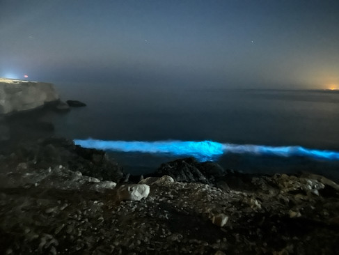
This a very popular spot for good reason! There are many places to camp along the cliff edge overlooking the beach. But if you want some space between you and your neighbor, get there by 3-4pm. In Februrary when we were there, we got to see bioluminesent waves as well!
Campsite: 22°53'39.8"N 59°13'19.0"E or see it here
Salma plateau


This plateau is super cool because of it wide, open views and cave exploration. The air is also a lot cooler because its at higher elevation (5400'). That being said, you will need to drive up some seriously STEEP, twisty gravel roads to get up there! If you have a 4x4 vehicle (preferable 4L), you won't have any problem with traction. Plus, the steepest corners are paved for added grip.
You can cover the entire main 'loop' in about 3-4 hours. We drove it counterclockwise, starting here. And then we chose a camp spot 3/4 of the way around the loop that was out of the wind and had a great view of the canyon.
NOTE: Google maps is not up to date on roads up here. Towards the middle of the loop, some roads are being replaced and the main loop road is being rerouted. Follow the most obvious road, even if your phone map makes it look like you're going nowhere. It will eventually reconnect with the main loop road and take you back towards the ocean.
Campsite: 22°51'58.5"N 59°10'33.5"E or see it here
Hidden Beach

We found this beach after trying to get a camp spot at Turtle beach. It was too rocky for our liking, plus the wrong time of year for turtles. So we backtracked to a few others closer to Sur and finally landed here, near this hidden small beach. Although there was a permanent camp set up near the water, it was vacant and quiet this night. And we were able to find a spot above it with a pretty good view.
Campsite location: 22°33'11.9"N 59°39'50.2"E or see it here
Wahiba Sands


You must spend at least one night in the desert when in Oman! Solo vehicle travel isn't advised, so we had the option of trying to find another couple to caravan with or go with a guide. We opted to go with a guide and do a tent camp experience. It was really fun and one of the highlights of our trip.
Campsite: 22°12'52.7"N 58°50'36.3"E or see it here

Bonus camp #1 - "Nice View Hairpin Camp" on the Saiq Plateau

We saw this camp spot as we were driving to and from Al Suwgra Village (which is pretty cool and worth the bumpy drive to see it). We opted to take a break from camping and stay at a hotel the night before. This camp site certainly earns it title because the view is terrific AND it's right on the sharp turn of the road. But it's quite a large area and after 4pm, no one but a few locals will be driving that road. It looked pretty amazing and if we had stayed up on the plateau another night, we would have camped here.
Campsite: 23°07'24.1"N 57°39'59.3"E or see it here
Al Ayn beehive area


As we were planning this trip, many blogs we referenced recommended camping near the Al-Ayn beehive tombs on the way to Wadi Damn. But the area was under construction at the time, so we couldn't get to them. We managed to find a different scenic spot to camp nearby.
Campsite: 23°13'32.2"N 57°02'17.5"E or you can see it here.
Bonus Camp #2 - "Watching Stars camp" - on the backroad to Jebel Shams

From the Wadi Damm pools, we took the back gravel road up to Jebel Shams. There has recently been an additional connection of the back gravel roads that lead up to the traditional (paved) Jebel Shams route. So if you have a 4x4, this is another scenic (bumpy) section to explore. Google maps may not show it completely going through and connecting, but it does. We drove past this site and wish we had an extra night to stay here. This canyon is shielded from city lights so I bet the star watching is terrific!
Campsite: 23°14'13.3"N 57°06'31.6"E or you can see it here
Jebel Shams


Anyone planning a camping tip in Oman knows about Jebel Shams! This high-altitude plateau has an amazing view of the canyon and is home of the infamous Balcony Walk trail. Camping up here is chilly at night, so plan accordingly! There are many camp spots along the cliff edge. But they begin to fill up as early as 3pm. We had a friend recommend the spot below. The access is a bit rocky in the first 50 yards. But it's a terrific location. And you might get some local visitors!
Campsite: 23°12'23.1"N 57°12'11.2"E or you can see it here.
Bonus camp #3 - Heading into Snake Canyon

This was a campsite we had pinned from our originally planned route. It seemed like it would have great canyon views and it was easy access to the start of the road that would lead down past Snake Canyon and back to Muscat. We ended up changing our plans and not camping here. But check it out if you're in this area. Bald Sayt looks to be a super interesting village to check out.
Campsite: 23°10'05.1"N 57°24'38.9"E or you can see it here
Feel free to check out some of our other travel itineraries
from all over the world!
AND
If you like van-camping, check out some of the cool road trips we've done in our Sprinter van !
PLUS
Are you a travel photographer who would love to brush up on your skills without 'breaking the bank'?
Check out these affordable Nature Photography Classes as well this live presentation series where professional photographers from around the world share their insights, processing techniques and creative tips.
Comments